This map was developed to help prospective applicants to NEVI funding opportunities and other interested parties identify eligible areas for EV charging infrastructure deployment. The map displays the highway corridors along which EV charging infrastructure will be installed under the NEVI program and the areas eligible for funding under each NEVI solicitation. The map also includes other supporting information to assist in site evaluations.
California’s National Electric Vehicle Infrastructure Funding Program Map
Users can click on layers in the menu to the right of the map to display the following information:
- Alternative Fuel Corridors in California (the federally designated routes eligible for EV charging infrastructure deployment under the NEVI program)
- Planned EV charging stations awarded through Round 1 (GFO-23-601) of California's NEVI funding program that are planned for deployment
- Planned EV charging stations awarded through Round 2 (GFO-24-606) of California's NEVI funding program that are planned for deployment
- NEVI 6 (GFO-25-603) Alternative Fuel Corridors
- NEVI 4 (GFO-25-604) and NEVI 5 (GFO-25-606) Project Regions
- NEVI 3 (GFO-25-602) Needed Locations
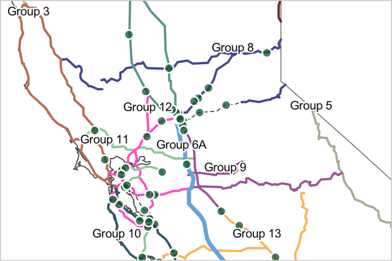
- Corridor Groups for previous NEVI solicitations: NEVI 2 (GFO-24-606) and NEVI 1 (GFO-23-601)
- Disadvantaged or low-income communities designated by California
- Federally recognized tribal lands
- California State Assembly districts
- California State Senate districts
- Congressional Districts (including California Temporary Congressional Districts)
- Counties
- Caltrans districts
- Electric load serving entities (IOU & POU)
- DC fast charging stations that meet NEVI power-level and port count requirements and are within one mile of a corridor off-ramp (as of March 2024)
Viewers can display Alternative Fuel Corridors (AFCs), NEVI 6 (GFO-25-603) Alternative Fuel Corridors, NEVI 4 (GFO-25-604) and NEVI 5 (GFO-25-606) Project Regions, NEVI 3 (GFO-25-602) Needed Locations, NEVI 2 (GFO-24-606) corridor groups and corridor segments, NEVI 1 (GFO-23-601) corridor groups, electric vehicle (EV) charging stations, Tribal lands, California-designated low-income or disadvantaged communities, California state legislative districts, counties, Caltrans districts, utility districts, and congressional districts in this interactive map. The map initially displays the AFCs and Project Regions for California’s Round 4 and Round 5 NEVI solicitations. Viewers can toggle individual layers on and off using the map layers menu located to the right of the map. Some layers are organized into groups; viewers can toggle all layers within a group or select specific ones. The legend to the left of the map will show the layers that have been turned on. There is a search tool to the right of the map that enables viewers to type in an address and locate the address on the map. A basemap selector allows viewers to view road detail. Additional information on the map can be found under the information icon. Viewers can download the map files by clicking on the Data and Supplemental Links icon.
Map layers include:
- A NEVI 6 (GFO-25-603) Alternative Fuel Corridors layer shows the Alternative Fuel Corridors eligible for Round 6 of California’s NEVI Funding Program.
- A NEVI 4 (GFO-25-604) / NEVI 5 (GFO-25-606) Project Regions layer shows the Project Regions for Round 4 and Round 5 of California's NEVI Funding Program.
- NEVI 3 (GFO-25-602) group labels for enhanced accessibility. Note that labels are only visible at certain ranges (zoom in and out to view labels).
- A NEVI 3 (GFO-25-602) Needed Locations layer shows the Needed Locations for Round 3 of California's NEVI Funding Program.
- An Alternative Fuel Corridors layer that shows designated corridors for California's NEVI funding program. Users can click on a corridor segment to view the start and end of each corridor. When selected, a pop-up window will appear that shows the corridor name and description.
- A NEVI 2 (GFO-24-606) corridor groups layer shows corridor groups and corridor segments eligible for Round 2 of California's NEVI funding program. Note that this layer is only visible when the Alternative Fuel Corridors layer is turned off.
- NEVI 2 (GFO-24-606) corridor group labels for enhanced accessibility. Note that labels are only visible at certain ranges (zoom in and out to view labels) and when the Alternative Fuel Corridors layer is turned off.
- NEVI 2 (GFO-24-606) corridor segment labels for enhanced accessibility. Note that labels are only visible at certain ranges (zoom in and out to view labels) and when the Alternative Fuel Corridors layer is turned off.
- A NEVI 1 (GFO-23-601) corridor groups layer that shows corridor groups eligible for Round 1 of California's NEVI funding program. Note that this layer is only visible when the Alternative Fuel Corridors layer is turned off.
- EV charging stations layers (existing DC fast charging stations that are located within one mile of a NEVI-eligible corridor offramp). One layer shows locations of EV charging stations with DC fast charging capabilities that meet the NEVI power level and four-port minimum requirement and could likely become part of the NEVI network if these stations became compliant with other NEVI program requirements such as data reporting. The other layer shows DC fast charging stations that do not meet NEVI power-level or port count requirements but could be upgraded to be NEVI-compliant. Users can click on EV charging stations and a pop-up window will appear with more information on the station (i.e., station address, total port count, minimum NEVI standard, etc.). These data were last updated in March 2024. Please refer to the Department of Energy's Alternative Fuels Data Center and PlugShare for up-to-date existing and planned DC fast charger site information.
- A layer showing the locations of EV charging stations awarded through Round 1 of California's NEVI funding program.
- A layer showing the locations of EV charging stations awarded through Round 2 of California's NEVI funding program.
- A layer showing California-designated disadvantaged or low-income communities.
- A layer showing California Federally Recognized Tribal Lands.
- A layer showing California State Senate Districts.
- A layer showing California State Assembly Districts.
- A layer showing California Congressional Districts.
- A layer showing California Temporary Congressional Districts.
- A layer showing California Counties.
- A layer showing Caltrans Districts.
- A layer showing Electric Utilities (IOUs and POUs).
Alternative Fuel Corridor - The U.S. Federal Highway Administration (FHWA) designates a national network of plug-in electric vehicle (EV) charging and hydrogen, propane, and natural gas fueling infrastructure along national highway system corridors. To designate these Alternative Fuel Corridors (AFC), FHWA solicits nominations from state and local officials and works with other federal officials and industry stakeholders.
California-designated Disadvantaged Communities - The California Environmental Protectional Agency (CalEPA) identifies four types of geographic areas as disadvantaged: (1) census tracts receiving the highest 25 percent of overall scores in CalEnviroScreen 4.0; (2) census tracts lacking overall scores in CalEnviroScreen 4.0 due to data gaps, but receiving the highest 5 percent of CalEnviroScreen 4.0 cumulative pollution burden scores; (3) census tracts identified in the 2017 DAC designation as disadvantaged, regardless of their scores in CalEnviroScreen 4.0; (4) and areas under the control of federally recognized Tribes.
California-designated Low-income Communities - Census tracts with median household incomes at or below 80 percent of the statewide median income or with median household incomes at or below the threshold designated as low income by the California Department of Housing and Community Development’s list of state income limits adopted under Health and Safety Code Section 50093.
Chargers – Manufactured units that safely deliver electricity to charge the battery of a plug-in electric vehicle. A charger may have one or multiple connectors. Often referred to as electric vehicle supply equipment.
Charging Station - A physical address where one or more chargers are available for use. A charging station can be public, shared private, or private.
Corridor Group - A group of one or more corridor segments.
Corridor Segment - A portion of a highway corridor.
DC Fast Chargers - Chargers that use direct current (DC) electricity at 480 volts to recharge an all-battery electric vehicle to 80 percent capacity in about 30 minutes, though the time required depends on the size of the vehicle battery and the power level of the charger.
Minimum Charging Stations Required - The minimum number of charging stations a corridor segment must have to be eligible for NEVI funding through California’s NEVI program solicitations.
Minimum Ports Required - The minimum number of new ports a corridor segment must have to be eligible for NEVI funding through California’s NEVI program solicitations.
Needed Locations - Locations required along a corridor segment, if applicable.
Project Regions - The regions that the state has been divided into for allocating funding under California’s NEVI 4 (GFO-25-604) and NEVI 5 (GFO-25-606) solicitations.
Solicitation - Grant Funding Opportunity, which refers to the solicitation document and all its attachments and exhibits.
GIS Shapefile Downloads:
Available on the California Energy Commission GIS Open Data Site (NEVI Category)
Supplemental Links:
- U.S. Department of Energy Alternative Fuels Data Center Station Data for Alternative Fuel Corridors
- U.S. Department of Transportation Federal Highway Administration Alternative Fuel Corridors
- California Air Resources Board California Climate Investments Priority Populations 2022 CES 4.0
- California Environmental Protection Agency Disadvantaged Communities Designation
Map last updated: March 2026. Subsequent updates will precede NEVI solicitation windows.
Data sources: Data are from the U.S. Federal Highway Administration’s Alternative Fuel Corridors website, the U.S. Department of Energy's Alternative Fuels Data Center Station Data for Alternative Fuel Corridors (as of March 2024), and the California Air Resources Board’s Map of California Climate Investments Priority Populations 2022 CES 4.0 (May 2022).
Citing: California Energy Commission (March 2026). California’s National Electric Vehicle Infrastructure (NEVI) Funding Program Map. Data last updated, March 2026.