This map was developed to help potential applicants of the California Energy Commission's REV 2.0 grant funding opportunity (GFO) identify eligible project sites for electric vehicle (EV) infrastructure deployment as described in the REV 2.0 GFO manual. The map displays several layers which represent the site eligibility requirements for this funding opportunity:
- Eligible rural and rural center tracts
- Disadvantaged (DAC) and/or low-income (LIC) communities, as defined by Senate Bill (SB) 535 and Assembly Bill (AB) 1550 and designated by the California Environmental Protection Agency (CalEPA) and the California Air Resources Board (CARB)
For a site to be eligible for this GFO, it must be located either in a rural tract or rural center tract. In addition, a minimum of 50 percent of a proposed project’s EV charging ports must also be located within either in a DAC and/or LIC.
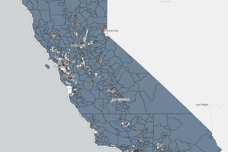
REV 2.0 Eligibility Map
Eligibility Map for the REV 2.0 Grant Funding Opportunity.
Viewers can display rural tracts, rural center tracts, and California-designated DACs and/or LICs.
The map will initially display rural and rural center tracts that are eligible for REV 2.0 GFO. Viewers can click on layers within the map layers menu to turn on the DAC and/or LIC layer. The legend will show layers that have been turned on. There is a search tool in the map that enables viewers to type in an address and locate the address on the map. Additional information on the map can be found under the About section. Viewers can download the map files from the REV 2.0 Eligibility Map Page, under the Additional Information about the Data accordion.
Rural Center
Contiguous urban tracts with a population of less than 50,000. Urban census tracts are tracts where at least 10 percent of the tract’s land area is designated as urban by the Census Bureau using the 2020 urbanized area criteria. Rural center census tracts are eligible for REV 2.0.
Rural
Census tracts that are not urban or rural centers. Rural census tracts are eligible for REV 2.0.
Disadvantaged Communities (DACs)
Communities disproportionately burdened by multiple sources of pollution and with population characteristics that make them more sensitive to pollution. Designated by the California Environmental Protection Agency per Senate Bill 535.
Low-Income Communities (LICs)
Census tracts with median household incomes at or below 80 percent of the statewide median income or with median household incomes at or below the threshold designated as low income by the Department of Housing and Community Development’s list of state income limits adopted under California Health and Safety Code Section 50093. Designated by CARB per Assembly Bill 1550 (Gomez, Chapter 369, Statutes of 2016).
Supplemental Links
- Locations of AB 1550 low-income communities and SB 535 disadvantaged communities
- Electric Vehicle Infrastructure Deployment Assessment (SB 1000)
Data last updated: December 2024
Data Collection Information
- United States Census 2016 Boundaries
- Locations of AB 1550 low-income communities and SB 535 disadvantaged communities
- Electric Vehicle Infrastructure Deployment Assessment (SB 1000)
- California Energy Commission GIS Open Data Site (REV 2.0)
Citing
Please cite use of these data and images. California Energy Commission 2025. California Energy Commission Rural Electric Vehicle Charging 2.0 (REV 2.0) Eligibility Map. Data last updated [insert date last updated]. Retrieved [insert date retrieved] from https://www.energy.ca.gov/data-reports/data-exploration-tools/rural-electric-vehicle-charging-20-rev-20-eligibility-map.